
 InSAR (Interferometric
Synthetic Aperture Radar)
InSAR (Interferometric
Synthetic Aperture Radar)
InSAR is a
dedicated, science-driven satellite mission that will provide dense
spatial (30 to 100 m) and temporal (every 8 days) measurements of the
North American and Pacific plates as they move past each other and deform
the surrounding regions. Precise comparisons of images acquired at
different times (repeat-pass interferometry) can reveal differential
horizontal and vertical motions accurate to 1 mm over all terrain types.
This new radar imagery, in concert with PBO’s continuous GPS and
strainmeter measurements, will enable mapping of surface displacements
before, during and after earthquakes and volcanic eruptions, providing
insights into fault mechanics and earthquake rupture. InSAR will enable
mapping of earthquake strain accumulation across broad, actively deforming
zones, highlighting regions of highest risk for future earthquakes. InSAR
will permit imaging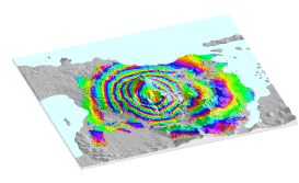 of the location and
migration of magma through a volcanic system that may lead to an eruption,
and will also provide a tool for mapping subsidence induced by petroleum
production and ground water
withdrawal.
of the location and
migration of magma through a volcanic system that may lead to an eruption,
and will also provide a tool for mapping subsidence induced by petroleum
production and ground water
withdrawal.