
 PBO (Plate Boundary Observatory)
PBO is a
distributed observatory of high-precision geodetic instruments designed to
image the ongoing deformation of western North America. The geodetic
network will extend from the Pacific coast to the eastern edge of the
Rocky Mountains, and from Alaska to Mexico. Two complementary
instrumentation systems—Global Positioning System (GPS) technology at
about 1000 sites, and ultra-low-noise strainmeters at 200 locations—will
provide superior time resolution. A sparse GPS network at 100-200 km
spacing, connecting about 20 dense clusters located at active volcanoes
and the most active earthquake faults, will provide complete spatial
coverage. PBO will significantly improve our ability to image and
characterize the slow deformation that accompanies earthquakes and
volcanic events. These data will elucidate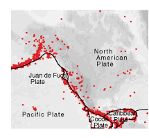 the poorly understood
processes that precede earthquakes and volcanic eruptions, and could
provide a firm basis for their prediction. The broad geographic coverage
will permit quantitative understanding of tantalizing connections observed
between activity in different regions. Complementary geological
investigations will link present-day deformation to longer-term processes
that have shaped the plate-boundary
region.
the poorly understood
processes that precede earthquakes and volcanic eruptions, and could
provide a firm basis for their prediction. The broad geographic coverage
will permit quantitative understanding of tantalizing connections observed
between activity in different regions. Complementary geological
investigations will link present-day deformation to longer-term processes
that have shaped the plate-boundary
region.