This software is OSI
Certified Open Source Software.
OSI Certified is a certification mark of the Open Source Initiative. Web services are a new type of Web applications that are self-contained, self-describing and modular. They can be published, located, and invoked across the Web and once the service is deployed, other applications can discover and invoke the deployed service. 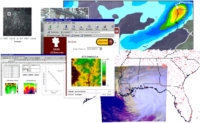 The web services implemented in the GIServer are an
example of the use of emerging standards such as SOAP in the
Geographic Information Science (GIScience) field. These new standards will
enable a new generation of "web services" that allow systems to make
remote procedure calls to other systems over the Internet. The web services implemented in the GIServer are an
example of the use of emerging standards such as SOAP in the
Geographic Information Science (GIScience) field. These new standards will
enable a new generation of "web services" that allow systems to make
remote procedure calls to other systems over the Internet. The application fields for the GIServer web services presented are the Earth Science and Environmental Spatial Information Systems. At present, most of these applications data are accessed off-line and due to the complexity of product format, algorithms and processing, the service provided to the user community is far from being optimal. Each user community has their own data applications with different knowledge extraction from the same raw data for specific applications. With actors ranging from data providers, scientists, value adding industry and citizens, several issues of accessibility are raised due to different scientific, conceptual and technological backgrounds. In effect, the key points in these applications data access are not only related to the raw data access per si, but in the system understanding of the user's final application and the added auxiliary services it might need. The same processing techniques or service might be used to achieve apparently different users objectives dependent only on the middleware applications available. These middleware applications will operate between the computing operating system and applications facilitating the collaborative work between the different actors. 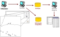 With the development of these OPEN
SOURCE GIS Web Services (see our BSD-like open source licensing)
we hope to contribute and develop a network of computers that will have
the purpose of resource sharing among different actors in a flexible,
secure and coordinated fashion. These actors might be individuals,
institutions or resources with different conceptual models about the data
and their inherent processing. In fact, the objective of this technology
is to be used in terms of network, distributed computing power and
collaborative environment that supports the final user community in their
own applications. With the development of these OPEN
SOURCE GIS Web Services (see our BSD-like open source licensing)
we hope to contribute and develop a network of computers that will have
the purpose of resource sharing among different actors in a flexible,
secure and coordinated fashion. These actors might be individuals,
institutions or resources with different conceptual models about the data
and their inherent processing. In fact, the objective of this technology
is to be used in terms of network, distributed computing power and
collaborative environment that supports the final user community in their
own applications. For the moment are available the following web sevices:
Note: SOAP (Simple Object Access Protocol) is a standard lightweight protocol for exchanging information in a decentralized, distributed environment. It uses XML to encode remote procedure calls and typically uses HTTP as a communications protocol. For more information about SOAP, see the SOAP specification available at http://www.w3.org/TR/SOAP/ Note: The basic idea behind open source is very simple: When programmers can read, redistribute, and modify the source code for a piece of software, the software evolves. People improve it, people adapt it, people fix bugs. And this can happen at a speed that, if one is used to the slow pace of conventional software development, seems astonishing. For more information about open source, go to the OpenSource.org web page. | ||||||||||||||
[top] |