|
|
|
OGC Compatible UDDI
Registries |
|
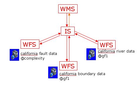
We illustrate a motivating scenario where Information Services interacts with Web Map Services and Web Feature Services
as in the figure below. In this scenario, Web Feature Services are published into the UDDI-Registry. Each Web Feature Service provides data layers corresponding to geographic entities. An important challenge is that UDDI does not natively support registry of services with a bounding box corresponding to a data layer and representing a location of interest. To overcome this problem, we use a standard capability of UDDI registries which is to classify service entries according to predefined taxonomies. We use geographic taxonomies to classify UDDI service entries based on spatial coverage. This methodology allows us to make coordinate based spatial queries on the UDDI-Registry. In Figure 4, Web Map Services interact with the Information Service to find out available Web Feature Services (data services) satisfying the data requirements of a map. As the Information Service responds a query of Web Map Services with metadata of services satisfying the query, Web
Map Services can then start interacting with corresponding Web Feature Service to acquire the data layers needed to create maps.
|
| |
|
|
How do Clients and
Publishers interact with UDDI Registries? |
|
|
|
| |
|
|
An Integrated
Demonstration to show the capabilities of an Information
Service |
|
|
|
| |
|
|